Glebe
Background
The word Glebe means ‘a piece of land serving as part of a clergyman's benefice and providing income’. Originally Gadigal and Wangal land, ‘The Glebe’ was 400 acres given by Governor Phillip to Reverend Richard Johnson, Chaplain of the First Fleet in 1790. The land remained largely undeveloped until 1828 when it was subdivided into 28 lots, three retained for church use. The point attracted the wealthy who built villas, the Broadway end attracted slaughterhouses and boiling down works that used the creek draining into Blackwattle Bay.
Exploring Glebe took place over two days; the first, the main part of the suburb using a wonderful Historical Walking Tour resource provided by the City Of Sydney Council as the guide for the day, the second day following the glebe foreshore with a resource provided by The Glebe Society.
We kicked off with a coffee at The Wedge, a great little café, having great flirty fun with the waiter. Highly recommended!


Past a few shops, including the famous Gleebooks, which opened as a second hand bookshop further up the road in 1975. Across the road is the Glebe primary school which opened in 1858. Weekly markets are held on Saturdays.


On towards the corner of Broadway, Parramatta Rd and Glebe Point Rd, ‘the gateway to Glebe’ where there are four historical sites:
University Hotel, a Victorian Italianate brick construction on sandstone, now University Hall accommodating students. It was built in 1889-90, the original four story façade is flanked by six storey additions constructed in the 1990s.
Glebe Jubilee fountain, erected in 1909,commemorating the 50th anniversary of Glebe Municipality.
A memorial to the indigenous boxer, Dave Sands. He had 87 wins, 10 losses, 1 draw and was recognised as one of the greatest boxers never to have won a world title. He was inducted into the World Boxing Hall of Fame in 1998 in Los Angeles and the Australian National Boxing Hall of Fame (Veterans) in 2009.
The stone marking the original western boundary of the City of Sydney bearing the name of Lt-Gen Richard Bourke, Governor of NSW 1831-37.
-
![Glebe Jubilee Fountain]()
Glebe Jubilee fountain
-
![University Hall, Glebe]()
University Hall
-
![]()
Dave Sands memorial
-
![]()
The stone marker


Around the corner into Derwent St where a WWI Memorial stands outside the back entrance of Glebe primary school. It has 303 names of those who served and formerly attended the school.

We meandered up Catherine St on to what had been Elsie, 73 and 75 Westmoreland St, disused houses set up as the first women’s and children’s refuge focused on domestic violence, which opened in 1974. Dr Anne Summers, Bessie Guthrie and Jennifer Dakers led a group of women to set up the refuge in response to the lack of services and support for women and children suffering from domestic violence. Initially there was no government support and a cricket bat at the door provided security. A visit by Bill Hayden, Social Security Minister in the Whitlam government shortly after it opened led to Elsie receiving Commonwealth funding and political recognition that domestic violence was not a private matter. The refuge relocated in 1975 to Derwent St and since 2014 has been managed by the St Vincent de Paul Society.

On to St John’s Road, the first stop was the Glebe Town Hall, built in stages from 1880-91. Glebe was a separate municipality from 1859 to 1949 when the City of Sydney took it over. In 1968, it became part of Leichhardt municipality then returned to the City in 1993. The Town Hall is a Council Neighbourhood Centre.
Around the corner was the Town Clerk’s House. We then passed the Glebe Fire station (sigh, I do love a fireman). Sadly the doors were shut and we couldn’t think of any reason to knock.
Just across the road on the corner of Derwent St was St John’s Parish Hall Bishopthorpe, also known as Record Reign Hall, built in 1897 to commemorate the diamond jubilee of Queen Victoria.
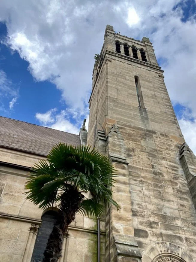
On the corner of Glebe Point Rd stands St John’s Anglican church, built in 1870, designed by the architect Edmund Blackett and completed by his sons. The first minister, William Macquarie Cowper was the first Australian born Anglican clergyman and godson of Lachlan Macquarie.
-
![Glebe Town Hall]()
Glebe Town Hall
-
![Glebe Town Hall]()
Glebe Town Hall, a different angle
-
![Town Clerk's House, Glebe]()
Town Clerk’s House, Glebe
-
![Glebe Fire Station]()
Glebe Fire Station, sigh
-
![St John's Parish Hall]()
St John's Parish Hall
-
![St John's church Glebe]()
St John’s Anglican church


Our second WWI memorial, flanked by the busts of a soldier and sailor and then the pretty Foley Park. The park was originally Hereford House, then a teachers’ college then a park named Glebe Rest Park. In 1964 it was named after Horace John Foley, a Glebe doctor, Glebe Council Member and Mayor. He provided free medical treatment for the poor but expected their loyalty in the ballot box.
The park contained the Rest Park Wireless House, opened in 1934, donated by Grace Brothers, to allow locals to listen to the radio between the hours of 10:00 am - 10:15 pm. It has been restored and is now an internet wireless hotspot.
-

The WWI war memorial with the busts of a soldier and sailor on either side
-

Girls under an arbour
-

Originally a radio for people to gather & listen, now a wireless hotspot
-

H J Foley park
We turned down Bridge Rd to the Reuss Houses and The Abbey. Ferdinand Hamilton Reuss built three houses between 1871 & 1877, considered the earliest examples of High Victorian architecture in Glebe. The Hermitage at 154 Bridge Rd, Hamilton at 156, Alma Villa at 158, Reussdale at 160. Alma Villa was demolished by the then Presbyterian Church and The Abbey was moved, stone by stone, from the corner of Glebe Point Rd and Parramatta Rd to this location in 1927. It was deconsecrated as a church in 1970 and became a popular Big Night Out restaurant from 1978 to 2004.
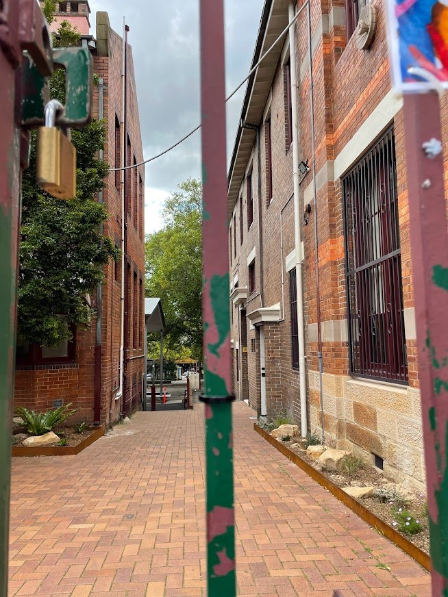
The laneway next door has been beautified with gardens, very peaceful.
-

The Hermitage, Glebe
-

The Abbey
-

Reussdale House, Glebe
-

The nearby laneway
We turned back to Glebe Point Rd, on the corner of Hereford Rd is a beautiful ‘Memories of Trams’ mural. It was painted by Kelly Wallwork in 2017, interpreted from a photo taken by Lenny Manny in 1953, commissioned by the Glebe Society. In addition, there are tram travellers’ stories recorded on the wall, a beautiful memento.
-

Memories of Trams mural
-

Stories of tram memories 1
-
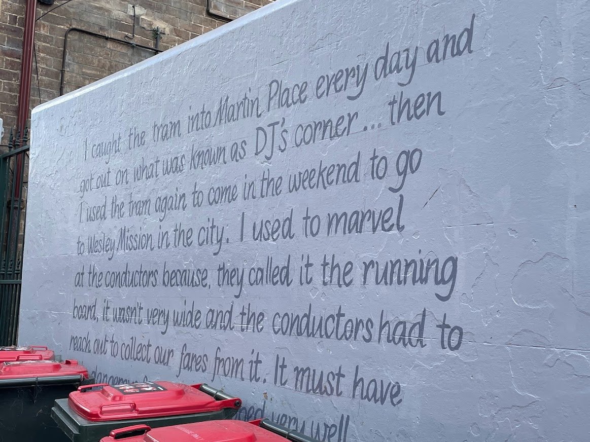
Stories of tram memories 2
-

Stories of tram memories 3
Across the road is another mural titled ‘Kelly and her gang’ , outside what was originally the Astor Cinema, then Filmor Red Star Cinema, New Arts Cinema, where the Rocky Horror Show ran for three years. It morphed into the Curzon Cinema and in 1979 became the Valhalla Cinema, success fully running until closure in 1999 and again in 2005. In 2007 the building was converted into office and retail space. Many of us recalled events we’d seen at the theatre.
-
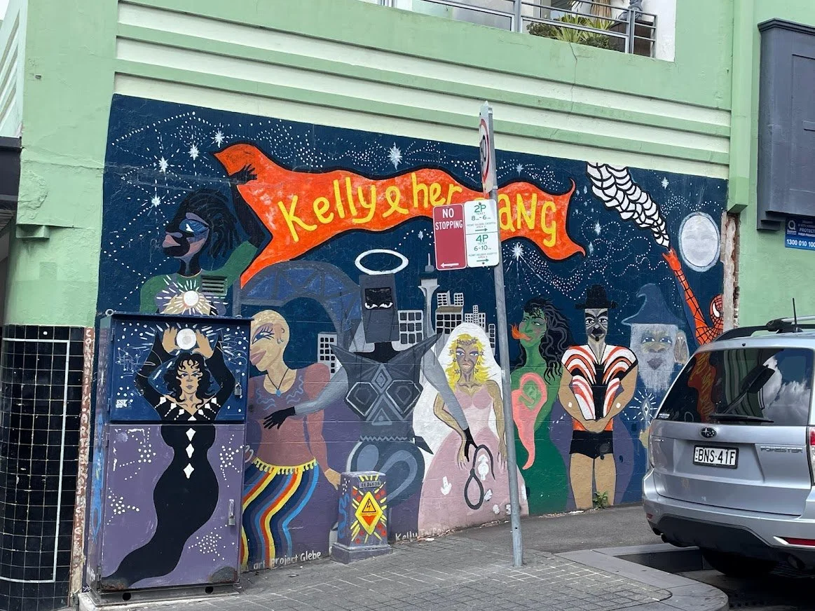
Kelly and her gang mural
-

Astor, the original name of the theatre
-

Valhalla theatre
Benledi House, 186 Glebe Point Rd was built in the late 1880s. It became a Homeopathic Hospital and general community hospital. It is now part of the Glebe library ‘an ideal venue for your community group’s meeting , seminar or gentle exercise class’.

Down to 13 Mansfield St to Tranby, built in 1858. Since 1958 it has been the home of the Tranby National Indigenous Adult Education & Training, providing vocational education and training to First Nations adults.


On to Toxteth Park, an historic house built for George Allen in 1829, the first solicitor to be trained in Australia. By 1831 he had acquired 96 acres of Glebe land which became the Toxteth Estate. In 1901, Toxteth Park was sold to the Sisters of the Good Samaritan and became part of St Scholastica’s College.

On to the Sze Yup Kwan Ti Temple, built from 1898 to 1904, a heritage listed Chinese joss house and Taoist temple. It is one of only four pre World War I Chinese temples that are active in Australia.

We headed to Bidura, 357 Glebe Point Rd, a heritage listed former residence, orphanage and office building, built and resided in 1860 by Edmund Blackett. Various other people owned the house until, in 1920 it was purchased by the NSW Government for use as accommodation for wards of the state. Originally called the Depot for State Children, also known as Bidura Orphanage or Glebe Girls Home (how sad).
It was the central point of child welfare in NSW, children who had committed crimes, those who were neglected or abandoned, from single parent families, had Aboriginal parents, or who were simply poor were processed the same way. Later Senate reports acknowledged the children here and at other locations ‘had experienced systems of care and societal attitudes that had utterly failed to protect them’. (How very sad.)
It closed as a residential facility in 1976/77 and was used for office space for the Department of Family and Community Services and contained a children’s court until 2017. A Development Application appears on the fence - who knows what the future holds?

We lunched at the Toxteth hotel, great service and good pub food with a touch of wine.
Finally some retail therapy at Kimona Lifestyle, where a number of us made purchases - a great find!
Back on the bus to home.


Glebe Foreshore
We set out on our second day in Glebe to explore the foreshore. Rozelle Bay originally had tidal swamps thickly covered with mangroves, the breeding ground of many forms of marine life and probably a major source of food source for the First Nations people. The foreshore was reclaimed, deepened and lined with straight stone seawalls for ships to be wharfed and maintained and for goods to be imported and exported. The parks we walked around were created progressively between 1880 and 1988.
We started with coffee at the Tramsheds, Maxwell Rd. The building was originally constructed in two sections, in 1904 and 1907, as the Rozelle Tram Depot. At that time Sydney had one of the largest tramway systems in the world, and the Rozelle Tram Depot supported trams from the Balmain and Drummoyne lines, with a capacity for 200 tramcars. It ceased operation in 1958. After many years of neglect and dilapidation, the building was restored by Mirvac and opened in 2016. It has won various design awards, including a National Trust award for Adaptive Re-use in 2017. Behind the Tramsheds is the residential development by Mirvac on the site of the old Harold Park Paceway Racecourse, originally known as Forest Lodge, which commenced in 1890 and ran its last race on 17 December 2010.

We left the Tramsheds and meandered down to Johnstons Creek (formerly Johnston’s Creek). The natural watercourse was converted into brick and concrete in the 1890s. The Johnstons Creek Aqueduct (along with White’s Creek Aqueduct) were the first reinforced concrete structures in Australia.
In 2009 a bull shark, believed to be 1.8 metres, was sighted in the Creek.
-

-

The viaduct was originally used for heavy rail, now the Inner West Light Rail travels on it
-

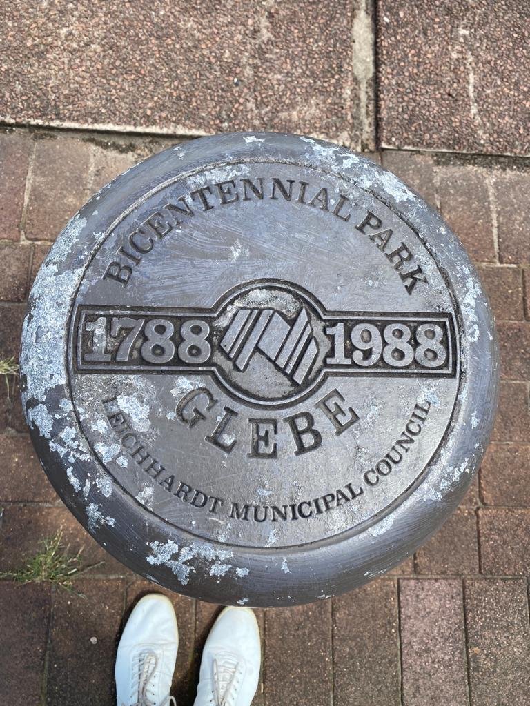
The beautiful parks of the area flow into each other. Starting with Jubilee Park, which commemorated the incorporation of the borough of Glebe (1859), created in 1909. We followed the Creek and passed through Bicentennial Park, designed by landscape architect Bruce McKenzie, created in 1988 to celebrate the Bicentenary of white settlement in Australia. It was the result of a 15 year campaign by The Glebe Society.

The next park, Pope Paul VI Reserve, named for the spot where the Pope landed in 1970 to visit the Royal Alexander Hospital for Children, located back then in Camperdown. Up until 1988 this was the only public access to the waterfront of Rozelle Bay. Two magnificent Moreton Bay Figs are illuminated at twilight, called Earth Vs Sky, created by the artist Allan Giddy in 2008, powered by a wind turbine
-

-

This wind turbine powers the lights that highlight the trees
-

Noxious industries were forced from the city in the 1820s and set up around the Glebe foreshores, discharging waste, polluting the bays and creeks and causing them to silt up. Around Blackwattle Bay were slaughter houses, tanneries, copper smelting, pig yards and tobacco factories and the infamous abattoir on Glebe Island. By the early 20th century pollution and health problems led to the curtailing of noxious industries. The bay was dredged to create deep water berths that were leased to maritime industries such as boat building, barges, timber yards and mills. These timber mills lined the foreshore from the 1890s until the 1980s, with timber storage dominating the water and land. The mills ceased operation in 1975 but some of the derelict buildings and storage remained. The timber often came from northern NSW and Queensland and was brought into the bay and logs left floating until they were dragged into the mills and sawn. Strides Crane and The Winch are one of the few remnants of that era.
The Winch commemorates Harbour Lighterage which repaired the floating platforms that brought the timber into the bay. The lighters (barges) were pulled up the slipway by the winch, for repairs. Stride’s Yard broke up coastal steamers to recycle metals, Stride’s Crane removed the engines
-

Strides Crane
-

Strides Crane from a different angle
-

The cable winch
-

Steps to the water
On the point is a sign marking Bellevue, a villa on two levels built in 1896 by architect Ambrose Thornley Jnr for William Jarrett, a publican and businessman who served on Glebe Council 1872-5. This house has great symbolic significance because it was saved from demolition by local resident action. It was acquired by Leichhardt Council in 1981 and given a new roof with money provided by the NSW Heritage Council. It then had to wait until 2005 to be restored by the City, which approved its use as a café in 2010. The café wasn’t open but the toilets were, thank goodness!


Just below the steps is the only public pontoon on the foreshore, built in 2009. In Blackwattle Bay Park near the end of Leichhardt Street is a plaque commemorating the efforts of the Glebe Society, unions and resident groups towards it creation. Until 2009 it was the only official recognition of the epic achievement of gaining complete public waterfront access. The Vanderfield and Reid timber mill once occupied this site.
In late 2019, an on-demand ferry service began running between the fish markets, Blackwattle Bay, Pirrama Park and Barangaroo. That service was scuppered in 2020 when the pandemic hit, but a trial restarted earlier this year, running every 30 minutes between Blackwattle Bay and Barangaroo. The journey takes 13 minutes. The NSW Government says it will only continue running if it’s used by 150 passengers a day. The local community hopes to promote the ferry’s existence to ensure it is able to continue running.
The Glebe Incinerator is one of the six remaining municipal incinerators designed by Walter Burley Griffin and his business partner, Eric Nicholls (1932). Griffin’s lifelong partner, Marion Mahoney, was by this time in India. She had done much of the design and most of the drawings for the competition they won for the design of Canberra. Incinerators such as these no longer operate because of their toxic fumes, but at the time they were regarded as a great improvement over dumping garbage at sea, which was the previous practice of Glebe Council.
There are signs all around the incinerator explaining its operation, and they are well worth reading, as they won an Architecture award for their interpretation of an industrial site. The rows of columns extending from the incinerator to the walkway are an interpretation of Council sheds designed by Griffin as part of his landscaping of the site. Griffin was a student of Frank Lloyd Wright, the most famous American architect, and his Australian designs reflect his interest in Mayan temples and the modernist Art Deco movement.


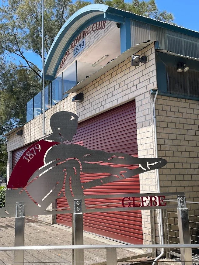
Our next stop was The Boatshed, once the Glebe Rowing Club, though not the original 1879 building, which burnt down and was replaced in 1956. The Rowing Club lost their lease and were supplanted by the Sydney University Women’s Rowing Club, Glebe Rowing Club found a new site within the Blackwattle Senior College Campus next door (one of a few schools with waterfront access) and built a new shed in 2005. The College stands on the site formerly occupied by the George Hudson timber mill, which experienced the first lockout of the Great Depression, in 1929.
The boardwalk took us over the water and in front of the Glebe Rowing Club, this section of the walk between the Clubhouse and Bridge Road is the most recent, and was completed in 2014. The new seawall was designed to included suitable habitats for marine species, and there is also a section where intertidal vegetation was planted, and adjoining that another planting of mangroves.
The iconic seafood restaurant, The Boathouse on Blackwattle Bay, with its legendary fish pie and wonderful oysters closed due to Covid-19 and failed leasing negotiations. What a loss, the building looks sad and empty.

We walked through Wentworth Park, created from Blackwattle swamp in 1880-82 (James Jones) and named after the Father of Representative Government in NSW, W.C.Wentworth. It predated Centennial Park, and was once elaborately landscaped. It was the site of the first Rugby League match in 1908 (another match was held on the same day at Birchgrove) and was the first home of the Glebe Cricket Club. Various dog races began there in 1932 and it became an American depot during WWII.
The Moreton Bay Figs alongside Bridge Road date from 1890 or the early 1900s.
Finally, off to lunch at the Glebe Hotel and home.


References
https://www.collinsdictionary.com/dictionary/english/glebe
https://en.wikipedia.org/wiki/Glebe,_New_South_Wales
https://www.cityofsydney.nsw.gov.au/history/history-walks
https://en.wikipedia.org/wiki/University_Hall_and_Cottages
https://dictionaryofsydney.org/entry/glebe_jubilee_fountain
https://en.wikipedia.org/wiki/Dave_Sands
https://glebesociety.org.au/socialhistory/glebes-first-world-war-memorials/
https://adb.anu.edu.au/biography/cowper-william-macquarie-3277
https://www.cityofsydney.nsw.gov.au/histories-local-parks-playgrounds/history-dr-h-j-foley-rest-park
https://artout.live/glebe/hereford-street-art/
https://en.wikipedia.org/wiki/Toxteth_Park,_Glebe
https://en.wikipedia.org/wiki/Sze_Yup_Temple
https://en.wikipedia.org/wiki/Bidura
https://en.wikipedia.org/wiki/Johnstons_Creek_(New_South_Wales)
https://www.broadsheet.com.au/sydney/city-file/article/group-glebe-residents-fighting-save-little-known-glebe-blackwattle-bay-ferry
https://www.broadsheet.com.au/sydney/food-and-drink/article/boathouse-blackwattle-bay-could-close-permanently-covid-19

Day 1

Day 2